How Do our North Carolina Fishing Maps work?

Below, you can read what’s Included with each and every fishing map area we offer. All fishing spot names and labels are “Matched” so switching between your mobile devices and your GPS to help navigate and find your fishing spots is easy as it gets.
Our fishing spots names and comments match on all files for all your mobile devices, including the printable lat/long file mentioned below. Best of all, everything is emailed to you in a single convenient ZIP file the same day of purchase. Works with most late Model GPS units and all Phones and Tablets with the free Google Earth App.
- Google Earth Fishing Map File – This file allows the use of multiple devices including iPhone, iPad, Droid, Android and computers supporting Google Earth. SEE THE SAMPLE HERE. Many kayak, wade fishermen and other inshore/near shore fishermen use their mobile device as fishing GPS with Google Maps to navigate to fishing spots. This file will also offer comments and fishing information on nearly each fishing spot from some of the best fishermen in North Carolina. This file has matching names and labels to co-exist with your other files. (Google Maps-Google Earth File included with any purchased fishing area)
- GPS Import/Upload File – No more manually entering dozens of GPS coordinates from paper fishing charts. Does your GPS accept and SD or Micro SD Card? Our specially created file is included with any purchase custom designed for YOUR GPS make and model and works with most GPS makes and models (post 2007) including; Garmin, Raymarine, Simrad, Lowrance and Humminbird GPS units using your SD card. See a North Carolina Fishing Map uploaded to a GPS Here. All Fishing spots and their names and comments on this GPS file will mathttps://ncfishingspots.com/wp-content/uploads/2013/09/north_carolina_fishing_maps.pdfch those on your Mobile Device File for convenient navigation. Also, your printable list of coordinates are label matched for easy cross referencing between all your mobile devoces and GPS unit(s) (all files included). Email with any questions: gpsfishingmaps@gmail.com
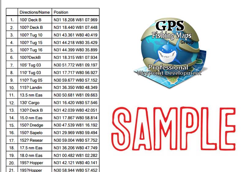
- Printable Matching Name and Label GPS Coordinates List – This is a PDF printable and viewable file with each and every fishing spot showing individual Lat/Long locations for manually entering GPS numbers into any GPS device or program in the world. All Labels and names on these fishing spots will match the fishing spots on your other files for ease of use to match your fishing spots throughout your area using any device you own. (this lat/long file is included with any purchased location)
- Fishing and Rigging Tutorials: That’s right, we have fishing and rigging tutorials for Offshore Trolling, Bottom Fishing and more. See how the pro’s rig for several types of offshore fishing and how they do it. These tutorials are included to match the fishing map area you have purchased. (fishing tutorials are included with any purchase)
Our Fishing Map system is proven and very easy to use and upload to your GPS and mobile devices, and most importantly, WE ARE HERE FOR YOU 12 hours a day. If you have problems loading our custom files on to any of your Devices or GPS units, we provide you access to our members portal with explicit upload instructions for each brand and model GPS, Phone and tablet. You’ll be on the water and on the fish in no time!
As of March 2013, we now celebrate 5-Years in the GPS Fishing Spots and Digital Fishing Map business with a 98% positive feedback rating from our customers throughout the southern states! This is a number we’re proud of, and we intend to keep it. Thank ALL of you for your business and support and we look forward to serving new customers this season!
Tight Lines and Good Fishing to All!
Please feel free to contact us with ANY questions you may have at gpsfishingmaps@gmail.com or phone our main office @ 912-580-5577, located in Amelia Island Florida.