North Carolina fishing spots
What’s included and how it works

Professional Level Fishing Spots for Professional Level Fishing Results!
North Carolina fishing spots are far more than a GPS toy for your devices. These proven fishing spots are a great way to cut your fuel burn and catch more fish. You can add more excellent fishing spots such as live bottom, offshore reefs, wrecks, ledges, outcroppings and more for bottom fishing, trolling and drifting from the beach to the ledge.
What’s it come with, exactly? – With any of our North Carolina fishing spots, you will receive everything you see below, all emailed the same day you purchase as a package ready to load to and SD card your GPS. And, files are ready to open with your mobile devices as well! For over 14 years, we’ve provided GPS fishing spots in many coastal states as the original and only company working with professional fishermen to bring you this format and top fishing spots. This combination provides or customers with the best fishing spots maps available for purchase.. Period.

Note about GPS SD Cards and GPS brands
Our fishing spots work with the following top name brands – (GPS views will vary greatly depending on your GPS mapping) Use our spots with Garmin, Humminbird, Raymarine touch/hybrid, Lowrance, Furuno TX touch models and Simrad GPS Map machines that accept an SD card.
 Preloaded GPS SD cards – Want our fishing spots loaded to an SD Card for your GPS? How to get it -During checkout, you will be prompted to add an SD card to your purchase. You may select that option or select the DIY GPS files only. GPS and Mobile files are emailed to you the same day you purchase, even if you choose the SD card option. SIMPLE. EASY!
1. North Carolina Fishing Spots for your boats GPS – Tired of entering coordinates for hours on end? If your marine GPS accepts an SD card, your dats of manually entering GPS coordinates are over! For all you DIY fishermen, we send specially designed copy and paste GPS files for your purchased fishing spots that import to your GPS for DIY fishermen. Simply use any blank SD card 32GB or less and a windows computer, and you’ll be able to copy the proper GPS file to your blank SD card, then into the GPS!
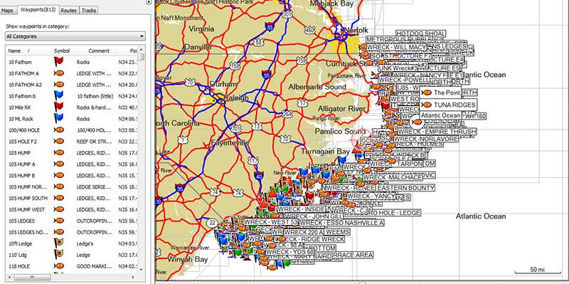
Once the GPS file is loaded, all the fishing spots will show on your map screen and your waypoints list! — See a GPS fishing spots sample loaded to a GPS (actual views vary greatly between brands and GPS models)

2. Use your Phone or Tablet as a GPS trip planner with the Navionics boating app! Also, use our included Google files with Google Earth Fishing on your Phone or computers. Simply install the Navionics boating app and grab the free Google Earth App and you’re ready to roll!
These files open very easily from the email we send with your mobile devices and Google Earth on most computers. Once opened in either app (Earth shown at left), the Fishing Spots will be usable on these devices when the user selects to do so..
If you don’t have Navionics or Google Earth on your device, simply get them from the app store on your device. The Fishing Map on the left here is an actual view of our Hatteras area Fishing Spots Map loaded to Navionics boating.

3. View comments on your North Carolina fishing spots – Most of our fishing spots have comments mentioning what type of bottom you can expect to find at that spot and other various details. Much of this info transfers to your GPS comment section (depending on how your GPS accepts comments) and comments are shown with a simple click in all the Google earth and Google Map Files on most devices. See a Sample of Fishing Spots Comments
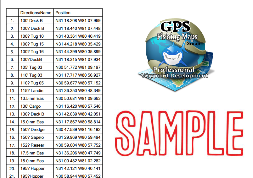
4. Label Matched, printable North Carolina GPS Fishing Coordinates file document for viewing or printing your Lat/Long coordinates, These printable and viewable coordinates are label matched and can be entered into most any GPS in the world. Print this and take it with you on the boat, or save the file for safe-keeping in case you ever need it for reference or you find the need for using the lat/long coordinates for your purchased area. See a GPS Coordinates Fishing Spots Sample List (Samples may be fictional fishing spots)
5. Advanced Fishing and Rigging Tutorials for nearshore and offshore fishing from North Carolina and the east in general. These tutorials are sent by request, so let us know and we’ll be happy to send them! Our guides have come together to compile excellent, detailed tutorials for those who need them to include tips on rigging for offshore bottom fishing, rigging and trolling on the East Coast and Coastal North Carolina. (Sent by request from the customer)
6. All the above mentioned files are included with all fishing spots we offer. These files are conveniently emailed the same day of purchase to get you on the water immediately. Note: For you convenience, these files are sent in a ZIP file for easy handling. We suggest un-zipping/Extracting the Files to an easy to find location, such as the desktop on your computer.
Questions? For fastest response, send an email anytime using our quick contact form here.